Maps
-
DaWrestla

- Red Dragon Priest
- Posts: 146
- jedwabna poszewka na poduszkę 70x80
- Joined: Mon Oct 03, 2005 8:05 pm
- Location: NJ
Maps
Does anyone know where I can see maps of each of the Lunar games? Specifically, I'd like to compare the maps of TSS and SSSC. Also, even EB and EBC.
-
localflick

- Black Dragon Wizard
- Posts: 495
- Joined: Thu Jul 21, 2005 7:07 pm
- Location: Chicago-ish
You might be interested in this thread. It started with a very similar question.
www.lunarthreads.com/viewtopic.php?t=703&start=0
www.lunarthreads.com/viewtopic.php?t=703&start=0
-
Alunissage

- Goddess
- Posts: 7353
- Joined: Thu Dec 26, 2002 10:31 am
Well, the thread you gave me was interesting. I remember when I played EBC I thought that vane was kind of in the wrong place. However, after reading other discussions in other threads, I think there is a good explanation for this:
1) I think the flood theory (floods changed the land between SSSC and EBC) hold some water (pun intended). I also think the angle theory (the SSSC and EBC maps are presented to the gameplayer on slightly different angles) also hold water. Having said that, I think it's logical that the floods could have moved Vane and/or Grindery/Taben's Peak.
2) In SSSC the Grindery was moved by the dragons, not steam (like in TSS). Nall resides in Taben's Peak sometime after SSSC. It might be fair to say that Nall moved Taben's Peak. (Obviously, being only one dragon, it would have taken a long time).
3) In actuality, I think this can all be easily explained by a combination of 1) and 2) above.
You know, I'm really starting to appreciate how well SSSC and EBC go together. All of the seeming inconsistencies are actually easily explainable (though I guess you could really do this for any series if you tried...I mean, just look at Zelda). However, I say this baring (sp) any concrete results on the whole multiple rebirths or not issue with Althena in SSSC...and the fact I haven't finished LDS.
EDIT: Actually, after looking at all the maps last night, it looks like there is massive flooding between LDS and SSSC and a drought between SSSC and EBC. So I guess the only thing that would hold is Nall moving the grindery for one reason or another. Oh, and if you rotate the EBC map a little counter-clockwise, the maps match up perfectly. However, I do have a problem with the Frontier being in the east in SSSC and in the west in LDS. Don't know how to explain that one.
Last edited by DaWrestla on Fri Oct 07, 2005 1:16 pm, edited 1 time in total.
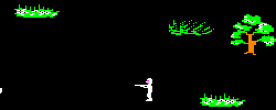
I've stitched together several hundred screenshots to get a largely complete map of Katarina, Marius, and Stadius (and it's HUGE). More than enough for comparing worldmaps, I think.
As I can't tell.... for you TSS experts out there, was the presumption in TSS that the Frontier bordered the main continent or that was far away?
The Frontier GIF alone is about 3000x2500 pixels or so.
As I can't tell.... for you TSS experts out there, was the presumption in TSS that the Frontier bordered the main continent or that was far away?
The Frontier GIF alone is about 3000x2500 pixels or so.
-
localflick
- Black Dragon Wizard
- Posts: 495
- Joined: Thu Jul 21, 2005 7:07 pm
- Location: Chicago-ish
The Frontier GIF alone is about 3000x2500 pixels or so.
That really is huge! If only there was a cheap way to print out a map that big. I'd imagine even if you had access to a printer that can create poster sized prints (or even tabloid sized prints for that matter) you'd still have to print out 5 - 6 sheets for the whole map. Depending on the resolution, you could cover a wall in Lunar!
Out of curiosity, how long did that take (ballpark)?
localflick wrote:I'd imagine even if you had access to a printer that can create poster sized prints (or even tabloid sized prints for that matter) you'd still have to print out 5 - 6 sheets for the whole map.
That's an interesting question. There are a few places around here with poster printers, I should inquire.
localflick wrote:Out of curiosity, how long did that take (ballpark)?
Atleast several hours; I'll put it up as-is if anyone is curious. (There are also a few Alex heads visible and places not accessible -- and thus not visible, but I will fix those later, again if anyone cares.)
But it's still not clear to me precisely how the Frontier and Katarina/Marius/Stadius connect, and Burg is presumably far away. Maybe should put that on, Hawaii or Alaska-style (in a little box in the corner).
-
GhaleonOne

- Ghost From The Past
- Posts: 9079
- Joined: Wed Dec 25, 2002 4:59 am
- Location: Not of this world...
-
Alunissage
- Goddess
- Posts: 7353
- Joined: Thu Dec 26, 2002 10:31 am
I would certainly love to have an electronic version of a screenshot map. That would make things much easier, especially since my sister borrowed my TSS guide several years ago. I should just buy another one.
I always had the feeling that the Frontier bordered the Stadius Zone, to the east. Though presumably Lunar is round and the ocean east of the Frontier also laps Caldor Isle's west shore.
There are maps on the site which give an idea of where most places are relative to each other...but the Frontier is presumably just offcamera.
G1 - the EB and TSS larger image links are reversed (clicking on the b&w TSS map shows you the EB one). And now that I have better programs I really should try to put those two EB and EBR maps together because as it is the two top halves are on the left and the bottom halves are on the right.
-
Kizyr

- Keeper of Knowledge (probationary)
- Posts: 8320
- Joined: Wed Dec 25, 2002 7:36 am
- Location: Marius Zone
- Contact:
With TSS, I got the impression that many of the places weren't entirely proportional. That is, it seemed like Caldor Isle was larger than it was since you 'zoomed in' more when you were there, whereas Katarina and the rest of the mainland was likely about the same. I'm remembering a few other locations, like the island off of Lann, that seemed bigger than it should be proportionally.
Plus that, the SSS novel indicates that there are plenty more islands out there than just Caldor. Caldor happens to be the main one. KF
Plus that, the SSS novel indicates that there are plenty more islands out there than just Caldor. Caldor happens to be the main one. KF
~Kizyr (they|them)
-
Alunissage
- Goddess
- Posts: 7353
- Joined: Thu Dec 26, 2002 10:31 am
-
phyco126

- Dragonmaster
- Posts: 8136
- Joined: Fri Dec 27, 2002 3:06 am
- Location: Colorado Springs, Colorado, USA
Well, we also must realize that if Lunar is round, you can't just make an accurate flat map. Remember geography classes where you had to learn about the different kinds of maps? How some are more accurate than others? Mostly because you can't take a round surface and make it perfectly flat.

- "Sometimes life smiles when it kicks you down. The trick is to smile back."
-
localflick
- Black Dragon Wizard
- Posts: 495
- Joined: Thu Jul 21, 2005 7:07 pm
- Location: Chicago-ish
I would certainly love to have an electronic version of a screenshot map.
Me too! I'd like to take the maps (after alex has been removed) and create an interactive Flash navigation piece. You could click on points of a smaller world map, and the huge one could show that place and give information on the area. Or make a Mapquest style map where you could zoom in on any area. There's potential for a lot of really fun stuff here. I want to work with it, but like my other side projects, it'll take a while since I work pretty much all the time now.
I was trying to figure out how Stadius and the Frontier connected; I've mapped out both continents entirely (in other words, these include the areas you can't normally see, which I found mildly interesting). Unlike the Katarina/Marius/Stadius maps, there do not appear to be any obvious shared points; however, looking at both maps, it would seem most likely that the Frontier is to the southeast, although at an unspecified distance.
Stadius: Full (GIF, 1.0MB, 2560x2176) Small (GIF, 142KB, 640x544)
Frontier: Full (GIF, 1.3MB, 3072x2688) Small (GIF, 224KB, 768x672)
This took a considerable chunk of time... so if you have any stunning revelations about the geography of Lunar or enhance/do anything interesting with it, I'd appreciate knowing (and having a copy of the updated map, if applicable.)
Oh, I have not made any effort to synchronize water/lava animation, if that matters to anyone. If it does, we'll see what we can do.
-
Kizyr
- Keeper of Knowledge (probationary)
- Posts: 8320
- Joined: Wed Dec 25, 2002 7:36 am
- Location: Marius Zone
- Contact:
DevNall wrote:I was trying to figure out how Stadius and the Frontier connected; I've mapped out both continents entirely (in other words, these include the areas you can't normally see, which I found mildly interesting). Unlike the Katarina/Marius/Stadius maps, there do not appear to be any obvious shared points; however, looking at both maps, it would seem most likely that the Frontier is to the southeast, although at an unspecified distance.
Ah, definitely... The mountain range between the two would make that the most obvious case.
You could also suppose that the Madoria Plains and the Plains around Pao are the same area, and connect a few more dots that way. That would require more analysis, though... KF
~Kizyr (they|them)
-
Alunissage
- Goddess
- Posts: 7353
- Joined: Thu Dec 26, 2002 10:31 am
I'm still inclined to think that Taben's tower = Mystic Ruins, although that would place Madoria Plains in the ex-Frontier.
How are you getting these, DevNall? The mountains west of Meryod look rather odd, with the wrong tiles. Is that what's "shown" when Stadius is loaded instead of Marius?
The water and lava desync does kinda drive me nuts, but don't tear your hair out fixing it for my sake; I'm still amazed and grateful that you did this at all. Were it to be put on the site and prettied up with some clickable stuff it might be good to fix.
Somewhere I have some files from an injoke-laden fangame some folks at the WDMB were doing a few years ago, which was also based on TSS; I'll have to see if there are any actual TSS maps in them or just altered versions.
Alunissage wrote:How are you getting these, DevNall? The mountains west of Meryod look rather odd, with the wrong tiles. Is that what's "shown" when Stadius is loaded instead of Marius?
To get to inaccessible places, I write a walkable "grid" into the section of RAM used for the map, then I have to walk in circles and wait for a random battle. I flee, then take a snapshot of the map (which gets refreshed after battle). Unfortunately, this sometimes means I get trapped, so I have to use the white dragon wings or reload from a save file and start again.
Anyway, yes, those land masses are loaded as part of the Stadius map. Yes, some of the maps have odd-looking places that are far away from anything accessible. Normally, you'd go through Meryod and get switched over to the Marius map. (I'll do Marius in the near future, it just has a blank land mass for the portions that are normally covered by Stadius beyond what you can normally see.)
Oh, and regarding the injoke-laden fangame, I'd love to see that (or anything used in it.)
Kizyr wrote:You could also suppose that the Madoria Plains and the Plains around Pao are the same area, and connect a few more dots that way. That would require more analysis, though..
That's the plan; it's hard to figure out what Lunar would look like between Lunar 1 and Lunar 2 without understanding the mapping between the worlds. Plus, it'll be interesting to see where things like the Blue Spire would be in the Lunar 1 World.
I also have an incomplete but very close combination map of Katarina, Marius & Stadius, though it's not pretty.
Say, anybody have a GENS save file for the Japanese Sega CD Eternal Blue? Something with most of the world map open and the Dragonship Destiny accessible?
Who is online
Users browsing this forum: No registered users and 53 guests